Lahar is an
Indonesian word for the slurry of pyroclastic material, debris and water that
flows down from a volcano. Most volcanic hazards occur during eruptions and/or
close to the volcanic vent, but lahars can occur years after an eruption and
flow more than 100 kilometres.
Flowing fast
and fierce
A lahar
starts as a mixture of pyroclastic material and water. The sediments are
unsorted (not layered by size) and highly unstable. When water mixes with lahar
deposits they move quickly, carrying sediments ranging from dust to boulders racing
down the side of the volcano. As this slurry of material moves down the slope,
it scours the land and picks up everything in its path – rocks, soil, buildings,
lakes and more. Some lahars can grow to 10 times their original size as they
rush down volcanic slopes. The consistency ranges from that of wet concrete
(thickest) to a thinner flow, more like motor oil.
Lahars may
be more than 100 m deep, depending on the amount of debris and the shape of the
valley or river that they flow in. Upon reaching a flat area, they spread out
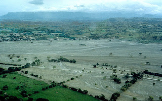
and can bury towns. One of the worst lahar disasters occurred with the eruption
of Nevado del Ruiz (Colombia) in 1985. More than 23,000 people were killed and
the town of Armero (centre of picture) was almost obliterated.
The eruption of Nevado del Ruiz on 13 November 1985,
triggered lahars that had travelled 100 km within four hours. The town of
Armero was consumed by this large lahar that was travelling at 60 km/hr (J
Marso, USGS 1985, public domain).
Water triggers
the flow
Lahars form
as debris mixes with water. The flow may be triggered by melting snow and ice
during an eruption. Water from a crater lake can mix with material during an
eruption or years later if the wall of the lake breaks. This occurred on New
Zealand’s, Ruapehu volcano and is shown well in the video link below.
Rainfall can
trigger lahar flow. The photo shows a raging lahar triggered by a minor
rainfall after the 1991 eruption of Mount Pinatubo. Large lahar flows occurred
for the four years after the eruption and remained a hazard for decades after.
This lahar on the east side of Mount Pinatubo moved at
3-5 m/sec and carried large boulders. It was triggered by a minor rainfall (C Newhall,
USGS 1991, public domain).
Webpage:
Video:
- Lahars on Ruapehu Volcano
(GNS Science)
Living
with lahars
Many areas
live with the threat of lahars, but the risk can be minimised. Lahars flow
through valleys and river channels. People should not build in these high-risk
areas including where they empty onto flat land. The town of Armero was built
on a lahar deposit from 1845 – a risky location.
Warnings of
volcanic eruptions allow an educated population to seek shelter and move away
from high risk areas. Communication needs to be clear and include pictures to
reach children and those who do not read the local language. If local
populations understand how to evacuate and take shelter, they can guide
tourists.
Engineering
solutions help minimise the risk of lahars in Indonesia and Japan. Structures
may be used to prevent lahar flow, weaken the force, block lahars before they
reach populated areas or divert lahars away from critical areas. The strategy
depends upon the cost of structures, risk to populations and probability of a
disaster if works are not carried out. Lahar channels on Mount Unzen direct
flows away from vulnerable areas.
A lahar channel at the base of the Unzen volcano helps to
direct flow away from populated areas. Large areas of pyroclastic and lahar
flow are show as brown sediment on the side of the mountain. (Chris 73 2007,
Wikimedia Creative Commons)
Learn
more about volcanoes
- Lahar in a Jar! (USGS) Explore the composition of lahars and learn about their impact in the Cascades area of the USA.
- Watch the Australian Earth Science Education video of Lahar in a Jar and try this at home.
- Create your own 3D volcano.
- Explore the shapes of different volcanoes.
- What is the relationship between steepness of slope and lava (or lahar) flow?
- Experiment with viscosity.
- Find out about volcano webcams around the world.
- Learn about the technologies used to predict natural hazards.


